Montegiovi
Jump to navigation
Jump to search
Montegiovi | |
|---|---|
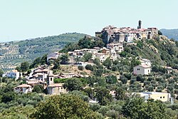
 View of Montegiovi | |
| Coordinates: 42°54′39″N 11°31′15″E / 42.91083°N 11.52083°E | |
| Country | Italy |
| Region | |
| Province | Grosseto (GR) |
| Comune | Castel del Piano |
| Elevation | 487 m (1,598 ft) |
| Population (2011) | |
| • Total | 175 |
| Demonym | Montegiovesi |
| Time zone | UTC+1 (CET) |
| • Summer (DST) | UTC+2 (CEST) |
| Postal code | 58030 |
| Dialing code | (+39) 0564 |
Montegiovi is a village in Tuscany, central Italy, administratively a frazione of the comune of Castel del Piano, province of Grosseto, in the area of Mount Amiata. At the time of the 2001 census its population amounted to 168.[1]
Montegiovi is about 50 km from Grosseto and 5 km from Castel del Piano, and it is situated on a hill in the western limit of Val d'Orcia.
Main sights
[edit]
- Church of San Martino (13th century), main parish church of the village
- Church of Madonna degli Schiavi (16th century), also known as Madonna delle Grazie, with frescoes by Francesco Nasini, it was re-built in the 19th century
- Chapel of Sant'Elena, ancient church at the service of the castle of Montegiovi
- Walls of Montegiovi, old fortifications which surround the village since the 12th century
- The Giardino di Piero Bonacina, a contemporary art garden with sculptures by artist Piero Bonacina.
References
[edit]Bibliography
[edit]- Aldo Mazzolai, Guida della Maremma. Percorsi tra arte e natura, Le Lettere, Florence, 1997
- Giuseppe Guerrini, Torri e castelli della Provincia di Grosseto, Nuova Immagine Editrice, Siena, 1999
See also
[edit]Wikimedia Commons has media related to Montegiovi.
