Anambra State
Jump to navigation
Jump to search
Anambra State
Ife Mbà (Igbo) | |
|---|---|
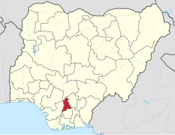
 Location of Anambra State in Nigeria | |
| Coordinates: 6°20′N 7°00′E / 6.333°N 7.000°E | |
| Country | |
| Geopolitical Zone | South East |
| Date created | 27 August 1991 |
| Capital | Awka |
| Number of LGAs | 21 |
| Government | |
| • Governor[1] | Charles Chukwuma Soludo (APGA) |
| • Deputy Governor | Onyeka Ibezim (APGA) |
| • Senators | |
| • Representatives | List |
| Area | |
| • Total | 4,844 km2 (1,870 sq mi) |
| • Rank | 35 |
| Population (2006 census) | |
| • Total | 4,177,821 |
| • Rank | 14th of 36 |
| • Density | 860/km2 (2,200/sq mi) |
| GDP | |
| • Year | 2021 |
| • Total | $33.26 billion |
| • Per capita | $5,231 |
| Time zone | UTC+01 (WAT) |
| ISO 3166 code | NG-AN |
| HDI (2018) | 0.662[2] medium · 3rd of 37 |
| Website | Official website |
Anambra State is one of the 36 states of Nigeria. The capital is Awka. Charles Chukwuma Soludo became the governor after Willie Obiano.
Activities
[change | change source]The State has many infrastructure and organizations including Anambra State Children's Parliament.
Reference
[change | change source]- ↑ See List of governors of Anambra State for a list of prior governors
- ↑ "Sub-national HDI - Area Database - Global Data Lab". hdi.globaldatalab.org. Retrieved 2018-09-13.
Other websites
[change | change source]- Official website Archived 2012-03-14 at the Wayback Machine