Chibed
Chibed
Kibéd | |
|---|---|
 | |
 Coat of arms | |
 Location in Mureș County | |
 Chibed Location in Romania | |
| Coordinates: 46°31′46″N 24°57′48″E / 46.52944°N 24.96333°E | |
| Country | Romania |
| County | Mureș |
| Government | |
| • Mayor (2020–2024) | Sándor Dósa[1] (UDMR) |
| Area | 380 km2 (150 sq mi) |
| Elevation | 384 m (1,260 ft) |
| Population (2021-12-01)[2] | 1,730 |
| • Density | 4.6/km2 (12/sq mi) |
| Time zone | EET/EEST (UTC+2/+3) |
| Postal code | 547268 |
| Area code | +(40) 265 |
| Vehicle reg. | MS |
| Website | kibed |
Chibed (Hungarian: Kibéd, Hungarian pronunciation: [kibeːd]) is a commune in Mureș County, Transylvania, Romania, composed of a single village, Chibed. It lies in the Székely Land, an ethno-cultural region in eastern Transylvania. The village is famous for the onion produced in the village and sold in front of the houses along the main road.
History
[edit]The village was historically part of the Székely Land in Transylvania and belonged to Marosszék in the Middle Ages. In the mid-1780s as part of the Josephine administrative reform, Marosszék was integrated into Küküllő County, however, the szék-system was restored in 1790. After the suppression of the Hungarian Revolution in 1849, the village formed part of the Kibéd military sub-division of the Marosvásárhely division in the Udvarhely military district.[3]: 1, figure 3 Between 1861 and 1876, the former Marosszék was restored.[3]: 2 [4] As a result of the administrative reform in 1876, the village fell within Maros-Torda County in the Kingdom of Hungary.[5]
In the immediate aftermath of World War I, following the declaration of the Union of Transylvania with Romania, the area passed under Romanian administration during the Hungarian–Romanian War of 1918–1919. By the terms of the Treaty of Trianon of 1920, Chibed became part of the Kingdom of Romania. During the interwar period, the village fell within Plasa Sângeorgiu de Pădure of Odorhei County. In 1940, the Second Vienna Award granted Northern Transylvania to Hungary and the territory was held by Hungary until October 1944, when it was taken back from Hungarian and German troops by Romanian and Soviet forces, and came under Romanian administration in March 1945.
In 1950, after Communist Romania was established, Chibed became part of the Odorhei Raion of Stalin Region. Between 1952 and 1960, the commune fell within the Magyar Autonomous Region, and between 1960 and 1968 the Mureș-Magyar Autonomous Region.[3]: figure 4 In 1968, the region was abolished,[6] and since then, the commune has been part of Mureș County, first as a component village of Ghindari and, since splitting away in 2003, as an independent commune.
Demography
[edit]| Year | Pop. | ±% |
|---|---|---|
| 1850 | 1,873 | — |
| 1880 | 2,003 | +6.9% |
| 1900 | 2,579 | +28.8% |
| 1910 | 2,633 | +2.1% |
| 1930 | 2,558 | −2.8% |
| 1956 | 2,681 | +4.8% |
| 1977 | 2,046 | −23.7% |
| 1992 | 1,854 | −9.4% |
| 2002 | 1,785[7] | −3.7% |
| 2007 | 1,721[8] | −3.6% |
| 2011 | 1,765[9] | +2.6% |
| 2021 | 1,730[10] | −2.0% |
| Source: Census data | ||
According to the 2011 census, the commune has a population of 1,765 of which 1,693 or 95.92% were Székely Hungarians. At the 2021 census, Chibed has a population of 1,730, of those, 95.26% were Hungarians.[10]
In 1910, the village had 2,633 Hungarian inhabitants, which made up 100% of the population.[7] In 1930, the census indicated 2,443 Hungarians (95.50%), 108 Gypsies (4.22%), and 6 Romanians (0.23%). In 2002, beside 1,780 Hungarians (99.72%), the village also had 5 Romanian (0.28%) inhabitants. At this time, 814 households were registered along with 802 residential buildings.[11] In 2007, the village had 1,721 inhabitants.[8]
Twinnings
[edit]The village is twinned with:
 Bakonyszombathely, Hungary
- Szatymaz, Hungary
- Zalalövő, Hungary
See also
[edit]Gallery
[edit]-
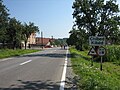 Bilingual signboard
 -
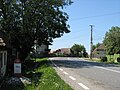 Main Road
 -
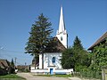 Reformed church
 -
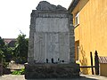 Heroes Memorial


External links
[edit]- Map of Mures County (in Hungarian and Romanian)
References
[edit]- ^ "Results of the 2020 local elections". Central Electoral Bureau. Retrieved 11 June 2021.
- ^ "Populaţia rezidentă după grupa de vârstă, pe județe și municipii, orașe, comune, la 1 decembrie 2021" (XLS). National Institute of Statistics.
- ^ a b c Tibor Elekes. "Marosvásárhely közigazgatási szerepe a XIV. századtól napjainkig" (PDF) (in Hungarian).
- ^ Gazetteer of Hungary, 1873 Archived 2008-10-29 at the Wayback Machine
- ^ Hungarian Administrative Reform Act 1876
- ^ James F. Brown. "The grooves of change: Eastern Europe at the turn of the millennium". Duke University Press. p. 54.
- ^ a b "Censuses in Mureș County, 1850 - 2002" (PDF). Archived from the original (PDF) on 2011-07-16. Retrieved 2010-08-15.
- ^ a b National Institute of Statistics of Romania Archived 2010-01-06 at the Wayback Machine
- ^ COMISIA JUDEȚEANĂ PENTRU RECENSĂMÂNTUL POPULAȚIEI ȘI AL LOCUINȚELOR
- ^ a b "Populația rezidentă după grupa de vârstă, pe județe și municipii, orașe, comune, la 1 decembrie 2021" (in Romanian). INSSE. 31 May 2023.
- ^ Miscellaneous information on the commune
