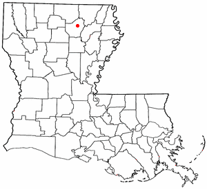
Monroe, Louisiana
The city of Monroe is the parish seat of Ouachita Parish, in the US state of Louisiana. It is the principal city of and is included in the Monroe, Louisiana Metropolitan Statistical Area, which is included in the Monroe-Bastrop, Louisiana Combined Statistical Area. A As of the 2000 census, the city had a total population of 53,107.
Monroe is the home of the University of Louisiana at Monroe (formerly known as Northeast Lousiana University). It also houses the headquarters of CenturyTel Communications, the eighth largest telecommunications provider in the nation. Monroe is situated on the Ouachita River and continues to serve as the population center and distribution outlet for the surrounding farming community.
Monroe and the neighboring town of West Monroe (pop. 13,250), which sits just across the Ouachita River, are often referred to as the Twin Cities of northeast Louisiana.
Home of Delta Air Lines
From 1926 to 1941, Monroe served as the home to Delta Air Lines until the company relocated to Atlanta, Georgia. Despite its small size Delta, until 2004, offered mainline jet service to the city. Monroe Regional Airport's logo is a "Delta" symbol and bears the statement "BIRTHPLACE OF DELTA AIR LINES" at the entrance and on its website.
Home of the First Coca-Cola Bottling Plant
Monroe is the site of the first Coca-Cola Bottling Plant
Geography

Monroe is located at 32°30'37" North, 92°5'42" West (32.510343, -92.094895)Template:GR.
According to the United States Census Bureau, the city has a total area of 83.9 km² (31.6 mi²). 74.3 km² (28.7 mi²) of it is land and 9.6 km² (3.7 mi²) of it is water. The total area is 11.46% water.
Demographics
As of the censusTemplate:GR of 2000, there are 53,107 people, 19,421 households, and 12,157 families residing in the city. The population density is 714.9/km² (1,851.8/mi²). There are 21,278 housing units at an average density of 286.5/km² (741.9/mi²). The racial makeup of the city is 36.78% White, 61.13% African American, 0.13% Native American, 1.05% Asian, 0.03% Pacific Islander, 0.25% from other races, and 0.63% from two or more races. 1.01% of the population are Hispanic or Latino of any race.
There are 19,421 households out of which 32.3% have children under the age of 18 living with them, 33.4% are married couples living together, 25.3% have a female householder with no husband present, and 37.4% are non-families. 31.3% of all households are made up of individuals and 11.7% have someone living alone who is 65 years of age or older. The average household size is 2.54 and the average family size is 3.26.
In the city the population is spread out with 29.7% under the age of 18, 15.0% from 18 to 24, 25.1% from 25 to 44, 17.5% from 45 to 64, and 12.8% who are 65 years of age or older. The median age is 29 years. For every 100 females there are 84.1 males. For every 100 females age 18 and over, there are 76.6 males.
The median income for a household in the city is $25,864, and the median income for a family is $33,263. Males have a median income of $31,840 versus $22,352 for females. The per capita income for the city is $15,933. 32.3% of the population and 26.3% of families are below the poverty line. Out of the total population, 45.3% of those under the age of 18 and 21.6% of those 65 and older are living below the poverty line.
Famous residents
- Carl Fontana (Jazz Trombonist)
- Kevin Griffin (Better than Ezra Guitar/Vocals)
- Hamid Drake (jazz drummer and percussionist)
- James Arthur Payne (Better than Ezra backup vocals/keyboard/guitar/harmonica)
- Susan Ward (Actress Movies/Soap Opras)
- Doug Pederson (Green Bay Packers Quarterback)
- Stan Humphries (San Diego Chargers Quarterback)
- Rudy Niswanger (Kansas City Chiefs Center)
- Eric Edwards (Arizona Cardnials Tight End)
- Bubby Brister (Denver Broncos Quarterback)
- Teddy Garcia (Houston Oilers Kicker)
- Pat Williams (Minnesota Vikings Defensive Tackle)
- Tim McGraw (Country Music Singer) (Start, Louisiana)
- Andy Griggs (Country Music Singer)
- Aeneas Williams (St. Louis Rams Safety)
- Odessa Turner (New York Giants Wide Receiver)
- Chuck Finley (St. Louis Cardinals Pitcher)
- Greg Jordan (Designer)
- Clay Jordan (Survivor Thailand)
- Harry W. Addison (Author)
- [[
- Karl Malone (Utah Jazz Power Forward)
- Bill Russell (basketball star)
- Huey P. Newton (Black Panthers founder)
- [