Havana
- This article is about the Cuban capital city. For other places named Havana, please see Havana (disambiguation)
Template:Cuba town infobox
Havana (Spanish in full: San Cristóbal de La Habana, usually shortened to just La Habana;
UN/LOCODE: CU HAV) is the capital of Cuba and, with a population of more than 2.2 million, is the largest city of both Cuba and the Caribbean. It is located just over 90 miles (144 km) south-southwest of Key West, Florida. The city of Havana ("Ciudad de la Habana") is one of the 14 provinces of Cuba.
It is located on the northwest coast of Cuba, facing the Straits of Florida, and is surrounded by the province of Havana to the south, east, and west.
History
Conquistador Diego Velázquez de Cuéllar founded Havana in 1515 on the southern coast of the island, near the present town of Surgidero de Batabanó. Havana moved to its current location on what was then called Carenas Bay in 1519. Havana was originally a trading port, and suffered regular attacks by buccaneer pirates and French corsairs. The city became the capital of the Spanish colony of Cuba in 1607, and the main port of the Spanish colonies in the New World. The city was officially designated as "Key of the New World and antemural of the West Indies" by the Spanish crown. Goods traded in Havana included gold and silver, alpaca wool from the Andes, emeralds from Colombia, mahoganies from Cuba and Guatemala, leather from the Guajira, spices, sticks of dye from Campeche, corn, manioc and cocoa. Shipments were received from large convoys of sailing ships guarded by Spanish military ships during the summer months.

Havana expanded greatly in the 17th century. New buildings were constructed from the most abundant materials of the island, mainly wood, combining various Iberian architectural styles, as well as borrowing profusely from Canarian characteristics. During this period the city also built civic monuments and religious constructions. The convent of St Augustin, El Morro Castle, the chapel of the Humilladero, the fountain of Dorotea de la Luna in La Chorrera, the church of the Holy Angel, the hospital of San Lazaro, the monastery of Santa Teresa and the convent of San Felipe Neri were all completed in this era.
In 1649 a fatal epidemic brought from Cartagena in Colombia, affected a third of the population of Havana. On November 30, 1665, Queen Mariana of Austria, widow of King Philip IV of Spain, ratified the heraldic shield of Cuba, which took as its symbolic motifs the first three castles of Havana: that of the Real Force, of Three Santos Reyes Magos del Morro and San Salvador de la Punta. The shield also displayed a symbolic golden key to represent the title of "Key of the Gulf".
In the middle of the 18th century, Havana, which by now had more than seventy thousand inhabitants, was seized by the British navy. The city was subsequently governed by Sir Georges Keppel on behalf of Great Britain. The episode began on June 6, 1762, when at dawn, an impressive British fleet, containing more than fifty ships and fourteen thousand men, drew into Cuban waters. The British seized the city as part of the Seven Years' War, opening it to free trade and bringing thousands of enslaved Africans to the island. In the middle of 1763, only a year after invading, the British returned Havana to the Spanish in exchange for Florida.
After regaining the city, the Spanish transformed Havana into the most heavily fortified city in the Americas. Construction began on what was to become the Fortaleza of San Carlos of the Hut, the biggest Spanish fortification in the New World. The work extended for eleven years and was enormously costly, but on completion the fort was considered an unassailable bastion and essential to Havana's defence. It was provided with a large number of cannons forged in Barcelona. Between 1789 and 1790 Cuba was apportioned into individual diocese by the Catholic Church. Shortly thereafter, Havana Cathedral was erected. On January 15, 1796, the remains of Christopher Columbus were transported to the island from Santo Domingo.

As trade between Caribbean and North American states increased in the early 19th century, Havana became a flourishing and fashionable city. Havana's theatres received the most distinguished actors of the age, and prosperity amongst the burgeoning middle-class led to new expensive classical mansions being erected. During this period Havana became known as the Paris of the Antilles.
The 19th century opened with the arrival in Havana of Alexander von Humboldt, who was impressed by the vitality of the port. In 1837, the first stretch of railroad was constructed, of 51 km, between Havana and Bejucal, which was used for transporting sugar from the valley of Guines to the port of the city. With this, Cuba became the fifth country in the world to have a railroad, and the first Spanish-speaking country. Throughout the century, Havana was enriched by the construction of additional cultural facilities, such as the theater Tacon, one of the most luxurious in the world, the Artistic and Literary Liceo (Lyceum) and the theater Coliseo. In 1863, the city walls were knocked down so that the metropolis could be extended. At the end of the century, the well-off classes moved to the quarter of the Vedado. Later, they emigrated towards Miramar, and today, increasingly on the west, they have settled in Siboney. At the end of the 19th century Havana saw the last moments of the Spanish colonization in America, which ended definitively when the United States warship Maine was sunk in its port, giving that country the pretext to invade the island. The 20th century began with Havana, and therefore Cuba, under occupation by the USA.
Under American influence, the city grew and prospered with numerous buildings in the 1930s, when sumptuous hotels, casinos and splendid night clubs were constructed. San Traficante took the roulette of the Sans-Souci, Meyer Lansky directed the Riviera, and Lucky Luciano, the National Casino. Before the hotels and restaurants, the Cadillac, Chevrolet and Buick park in triple line waiting, to the buttons. At that time Havana became an exotic capital of gambling and corruption. A gallery of black and white portraits from the era still adorns the walls of the bar of the National Hotel, including pictures of Frank Sinatra with Ava Gardner, Marlene Dietrich and Gary Cooper: both gangsters and stars were known to mix socially in the city.
After the revolution in 1959 big transformations occurred, principally affecting the services and the construction of social housing and official buildings, but, as for the topography of Havana, it is possible to keep on describing in accordance with the same big areas of 1958. In 1991, the Pan American Games were held in Havana.
General

Havana City is the smallest of the Cuban provinces, but the most populated. There are different architectonic styles in the city, from houses of the XVII to modern constructions. Havana is the most important destination for tourists in Cuba and one of the most important in the Caribbean. It is also the main base for the government of the country, and various ministries are based in the city, as are the head offices of businesses such as Corporacion Cimex. The industries in Havana are an important part in the economy of the country. Havana’s harbor is the most important in Cuba and through it come and go half of the Cuban imports and exports.
On the night of July 8-9, 2005, the eastern suburbs of the city took a direct hit from Hurricane Dennis, and in October 2005, the coastal regions suffered severe flooding following Hurricane Wilma.
Transportation
- Havana's international airport is José Martí International Airport. It lies about 10 km south of the city center, and is the main hub for Cubana de Aviación.
- Buses - Havana's bus service is well used, and buses are often very crowded. The bus service operates fixed routes.
- Camellos - These are trailers transformed into buses, known as camels, so called for their two humps. The "camel buses" usually cover the longer routes to the outskirts.
- Colectivos - The Colectivos are taxis that operate long and fixed routes, only embarking when complete with passengers. These taxis are cheaper than the buses, and drivers wait in the surroundings of the bus stations.
- Ferry - The passenger ferry travels to Regla and Casablanca every 10 or 15 minutes from Muelle Luz, San Pedro and Santa Clara corner, in the Southeast of Old Havana.
Municipalities

The city is divided into 15 municipios - municipalities or boroughs.
- Arroyo Naranjo
- Boyeros
- Centro Habana
- Cerro
- Cotorro
- Diez de Octubre
- Guanabacoa
- La Habana del Este
- La Habana Vieja (Old Havana)
- La Lisa
- Marianao
- Playa (includes Miramar, and extends to Santa Fe in the west)
- Plaza de la Revolución (sometimes abbreviated to 'Plaza'; includes Vedado)
- Regla
- San Miguel del Padrón
Landmarks
- Malecón is the avenue that runs along the seawall at the northern shore of Havana, from Habana Vieja to the Almendares River.
- Old Havana and its fortifications, inscribed in the UNESCO World Heritage List in 1982.
- Castillo del Morro, picturesque fortress guarding the entrance to Havana bay.
- La Cabaña fortress, located on the east side of the Havana bay.
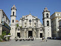
- Catedral de San Cristóbal, the most prominent building on the Plaza de la Catedral.
- The Museum of the Revolution, located in the former Presidential Palace, with the boat Granma on display in front of the museum.
- National Capitol, styled after the U.S. Capitol.
- Plaza de Armas - the main touristic square.
- Gran Teatro de la Habana, The Grand Theater of Havana is famous, particularly for the acclaimed National Ballet of Cuba and its founder Alicia Alonso, it also performs sometimes the National Opera. The theatre is also known as concert room, Garcia Lorca, the biggest of Cuba.
- Tropicana - tropical cabaret with a 60 year old history.
- Necropolis Cristóbal Colón - burial grounds and open air museum[1]
- Havana has a series of beaches spread out along the Via Blanca highway east of the city.
Sister Cities
Trivia
- Havana was a candidate to host the 2012 Summer Olympic Games, but was not shortlisted.
Other images
-
Vedado, Havana downtown district
-
 Habana Libre Hotel in Vedado
 -
Havana, Capitol Building
-
 Havana's Cathedral
 -
Gran Teatro de la Habana (Teatro Garcia Lorca)
-
Paseo del Prado
-
 El Templete
 -
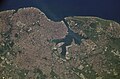 Havana from space


References
 Definitions from Wiktionary
 Media from Commons
 News from Wikinews
 Quotations from Wikiquote
 Texts from Wikisource
 Textbooks from Wikibooks
 Resources from Wikiversity
- The Rough Guide to Cuba (3rd ed.). Rough Guides, May 2005. ISBN 1-84353-409-6.
- Barclay, Juliet (1993). Havana: Portrait of a City. London: Cassell. ISBN 1844031276 (2003 paperback edition). — A comprehensive account of the history of Havana from the early 16th century to the end of the 19th century.
- Carpentier, Alejo. La ciudad de las columnas (The city of columns). — A historical review of the city from one of the major authors in the iberoamerican literature, a native of this city.
- Eguren, Gustavo. La fidelísima Habana (The very faithful Havana). — A fundamental illustrated book for those who wants to know the history of La Habana, includes chronicles, articles from natives and non natives, archives documents, and more.
External links
- Template:Wikitravel
- Map of Havana. To zoom in, click on an area of the map. These are very large High resolution JPEG images (~1 Megabyte)
- Photos of people and Sights in Havana
- Google maps
- Award-winning Cuba documentary
- A guide to the old part of the City
- Complete guide to Havana, Cuba