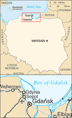
Gdańsk Bay

The Bay of Gdańsk (also known as the Gdańsk Bay or Gulf of Gdańsk; in Polish Zatoka Gdańska; in German Danziger Bucht) is a southeastern bay of the Baltic sea enclosed by a large curve of the shores of Gdańsk Pomerania in Poland (Cape Rozewie, Hel Peninsula) and the Kaliningrad Oblast of Russia (Sambian peninsula).
The western part of Gdansk Bay is formed by the shallow waters of the Bay of Puck and the southeastern part is the Vistula Lagoon, separated by the Vistula Spit and connected to the open sea by the Strait of Baltiysk. The maximum depth is 120 m, salinity 0.7 per cent.
The Bay of Gdansk receives the waters of the River Vistula directly via three branches -- the Leniwka, the Smiala Wisla, and the Martwa Wisla -- and indirectly via the Vistula Lagoon with 2 branches: the Nogat and the Szkarpawa.
Major ports are Kaliningrad, Gdansk, Gdynia, Puck, and Hel.
The bay features two very long sandspits, the Hel peninsula and the Vistula Spit. The first forms the Bay of Puck while the latter defines the Vistula Lagoon, accessed through the Strait of Baltiysk.
Coastal cities include: Gdansk, Gdynia, Sopot, Pilawa, and Hel. Rivers: the Pregolya and the Vistula. [[pl:Zatoka Gda%F1ska]]