Hinunangan

From Wikipedia, the free encyclopedia

This is an old revision of this page, as edited by 24.180.61.26 (talk) at 14:38, 11 July 2006. The present address (URL) is a permanent link to this revision, which may differ significantly from the current revision.

Jump to navigation Jump to search
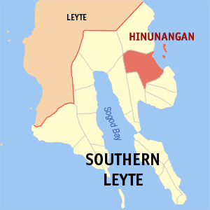
Map of Southern Leyte showing the location of Hinunangan

Hinunangan is a 4th class municipality in the province of Southern Leyte, Philippines. According to the 2000 census, it has a population of 25,016 people in 5,438 households.

Hinunangan is known as the "Rice Granary of the Province" for its vast plain land that is entirely planted with rice. Hinunangan is one of the key towns of the province, has great potential for tourism because of its seemingly beautiful beaches and islands.

Barangays

Hinunangan is politically subdivided into 40 barangays. Two if which barangays is a twin island located at the east of the town.

  • Ambacon
  • Badiangon
  • Bangcas A
  • Bangcas B
  • Biasong
  • Bugho
  • Calag-itan
  • Calayugan
  • Calinao
  • Canipaan
  • Catublian
  • Ilaya
  • Ingan
  • Labrador
  • Lumbog
  • Manalog
  • Manlico
  • Matin-ao
  • Nava
  • Nueva Esperanza
  • Otama
  • Palongpong
  • Panalaron
  • Patong
  • Poblacion
  • Pondol
  • Salog
  • Salvacion
  • San Pablo Island
  • San Pedro Island
  • Santo Niño I
  • Santo Niño II
  • Tahusan
  • Talisay
  • Tawog
  • Toptop
  • Tuburan
  • Union
  • Upper Bantawon
  • Libas