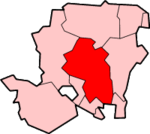
City of Winchester
| City of Winchester | |
|---|---|
 Shown within Hampshire | |
| Geography | |
| Status: | City |
| Region: | South East England |
| Admin. County: | Hampshire |
| Area: - Total |
Ranked 62nd 660.97 km² |
| Admin. HQ: | Winchester |
| ONS code: | 24UP |
| Demographics | |
| Population: - Total (2004 est.) - Density |
Ranked 185th 111,000 168 / km² |
| Ethnicity: | 97.8% White |
| Politics | |
| Arms of Winchester City Council Winchester City Council http://www.winchester.gov.uk | |
| Leadership: | Leader & Cabinet |
| Executive: | Conservative |
| MP: | Mark Oaten |
The City of Winchester is a local government district in Hampshire, England, with city status. It covers an area of central Hampshire including the city of Winchester itself (see the Winchester article for the main description of the city), and neighbouring towns and villages including New Alresford, Colden Common and Bishops Waltham.
The current city boundaries were set on April 1, 1974 when the City of Winchester merged with Droxford Rural District and part of Winchester Rural District.
Settlements and parishes
Settlements in the district include:
- Avington
- Badger Farm, Beauworth, Bighton, Bishops Sutton, Bishops Waltham, Boarhunt, Bramdean
- Cheriton, Chilcomb, Colden Common, Compton and Shawford, Corhampton and Meonstoke, Crawley, Curdridge
- Denmead, Droxford, Durley
- Easton, Exton
- Hambledon, Headbourne Worthy, Hursley
- Itchen Abbas, Itchen Stoke, Itchen Valley
- Kilmiston, Kings Worthy
- Littleton and Harestock
- Martyr Worthy, Micheldever
- New Alresford, Northington
- Old Alresford, Olivers Battery, Otterbourne, Ovington, Owslebury
- Shedfield, Soberton, Southwick and Widley, South Wonston, Sparsholt, Swanmore
- Tichborne, Twyford
- Upham
- Warnford, West Meon, Wickham, Wonston
