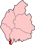
Borough of Barrow-in-Furness
| Borough of Barrow-in-Furness | |
|---|---|
 Shown within Cumbria | |
| Geography | |
| Status: | Borough |
| Region: | North West England |
| Admin. County: | Cumbria |
| Traditional County: | Lancashire |
| Area: - Total |
Ranked 272nd 77.87 km² |
| Admin. HQ: | Barrow-in-Furness |
| ONS code: | 16UC |
| Demographics | |
| Population: - Total - Density |
Ranked 311th 71,980 Ranked 147th / km² |
| Ethnicity (2004 estimate) |
Ranked 333rd in 2001 95.17% White British 1.67% White Other 1.21% Mixed Race 0.63% S.Asian 0.57% Chinese 0.54% Afro-Carib. 0.21% Other |
| Politics | |
| The crest of Barrow-in-Furness features a bee and an arrow and is an example of a "punning" coat-of-arms File:Arms-barrow.jpg.
| |
| Leadership: | Alternative - Sec.31 |
| Control: | |
| MP: | John Hutton |
Barrow-in-Furness is a local government district and borough in the administrative county of Cumbria, and the historic County of Lancashire, England. It is named after its main town, Barrow-in-Furness. Other settlements include Dalton-in-Furness, Roose and Askam-in-Furness. It is the smallest borough in the county, but is the most densely populated, with 924 people per square kilometre. The population was 71,980 in 2001 [1]
The area covered by the district is at the edge of the Furness peninsula. It jolts into the Irish Sea, being north of Morecambe Bay and south of the Duddon Estuary. This area is still part of the historic County Palatine of Lancashire but is no longer governed by Lancashire County Council.
The current borough was formed on April 1, 1974 by the merger of the former county borough of Barrow-in-Furness and the Dalton-in-Furness urban district.
In 2006, its council was fined £125,000 for violation of health and safety laws that lead to the deaths of seven people in the UK's worst outbreak of Legionnaires' disease. The council also became the UK's first public body to be charged with corporate manslaughter, but was found not guilty.
Areas/ Wards of Barrow Borough Council
Barrow-in-Furness total population 71,980
Barrow Island Ward 2,606
Central Ward 5,585
Dalton North Ward 6,599
Dalton South Ward 6,200
Hawcoat Ward 5,308
Hindpool Ward 5,515
Newbarns Ward 5,913
Ormsgill Ward 5,961
Parkside Ward 5,742
Risedale Ward 5,663
Roosecote Ward 5,501
Walney North Ward 5,604
Walney South Ward 5,784
History subsequent to the formation of the borough
- 1974 - The Borough of Barrow-in-Furness is formed
- 1983 - Barrow's once booming iron and steelworks industries disappeared, after being the worlds largest for many decades [2]
- 1985 - Natural Gas was discovered in Morecambe Bay, with the products processed onshore at the gas terminal in Rampside, south of the town [3]
- 1991] - After the end of the Cold War, Barrow's shipyards saw a decline in demand for military ships and submarines [4]
- 2002 - Barrow suffers from the worst ever Legionnaires' Disease outbreak, with seven deaths and 172 cases
- 2007 - Barrow begins major regeneration projects [5], as well as expanding the already record breaking Shipyard [6].
Barrow compared
Population, Area and Density
| Region | Population | Area | Population Density |
|---|---|---|---|
| Barrow-in-Furness | 71,980 | 77.87 km² | 900 / km² |
| Cumbria | 498,800 | 6,768 km² | 73 / km² |
| United Kingdom | 60,209,500 | 244,820 km² | 243 / km² |
Ethnic Diversity
| Region | White British | White Other | Mixed race | Asian | Afro-Caribbean | Chinese | Other |
|---|---|---|---|---|---|---|---|
| Barrow-in-Furness | 95.17% | 1.67% | 1.21% | 0.63% | 0.57% | 0.54% | 0.21% |
| Cumbria | 98.00% | 0.90% | 0.62% | 0.23% | 0.13% | 0.20% | 0.10% |
| United Kingdom | 85.70% | 6.50% | 1.20% | 3.60% | 2.30% | 0.40% | 0.80% |
Religion
| Religion | Barrow-in-Furness | United Kingdom |
|---|---|---|
| Christian | 81.0% | 71.6% |
| Muslim | 0.3% | 2.7% |
| Hindu | 0.1% | 1.0% |
| Jedi | N/A | 0.7% |
| Sikh | 0.0% | 0.6% |
| Jewish | 0.0% | 0.5% |
| Buddhist | 0.1% | 0.3% |
| Other religion | 0.1% | 0.3% |
| Not stated | 7.6% | 7.3% |
| No religion | 10.8% | 15.5% |
| Total religious | 81.6% | 76.8% |
