Greenfield, Ohio
Greenfield, Ohio | |
|---|---|
| Motto: "A Perfect Place To Raise A Family" | |
 Location of Greenfield, Ohio | |
| Country | United States |
| State | Ohio |
| Counties | Highland, Fayette, Ross |
| Area | |
| • Total | 2.06 sq mi (5.34 km2) |
| • Land | 2.06 sq mi (5.34 km2) |
| • Water | 0 sq mi (0 km2) |
| Elevation | 912 ft (278 m) |
| Population | |
| • Total | 4,639 |
| • Estimate (2012[3]) | 4,562 |
| • Density | 2,251.9/sq mi (869.5/km2) |
| Time zone | UTC-5 (Eastern (EST)) |
| • Summer (DST) | UTC-4 (EDT) |
| ZIP codes | 45123, 45165 |
| Area code | 937 |
| FIPS code | 39-32088Template:GR |
| GNIS feature ID | 1064755Template:GR |
| Website | http://www.greenfieldohio.net http://www.greenfieldohio.com |
Greenfield is a village in Highland, Fayette, and Ross counties in the U.S. state of Ohio, along Paint Creek, a tributary of the Scioto River. The population was 4,639 at the 2010 census. Although the municipality is listed as a city by the Census Bureau,Template:GR by Ohio law it officially became a village when its population dropped below 5,000.[4]
History
Much of Greenfield's early history concentrates on the Travellers' Rest Inn at the eastern end of Jefferson Street: built in 1812, it was the village's first stone building. It also served as its first post office, and was the space for its first doctor's office.[5] Now operated as a museum,[6] the inn is listed on the National Register of Historic Places. The Samuel Smith House and Tannery is also listed on the National Register.[7]
Geography
Greenfield is located at 39°21′6″N 83°23′11″W / 39.35167°N 83.38639°W (39.351623, -83.386461),Template:GR almost entirely in Highland County.[8]
According to the United States Census Bureau, the city has a total area of 2.06 square miles (5.34 km2), all of it land.[1]
-
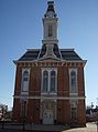 Clock tower in central Greenfield
 -
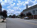 Intersection of Jefferson Street and Washington Street (central business district) in Greenfield


Demographics
2010 census
As of the census[2] of 2010, there were 4,639 people, 1,829 households, and 1,148 families residing in the city. The population density was 2,251.9 inhabitants per square mile (869.5/km2). There were 2,141 housing units at an average density of 1,039.3 per square mile (401.3/km2). The racial makeup of the city was 95.9% White, 1.7% African American, 0.1% Native American, 0.2% Asian, 0.3% from other races, and 1.7% from two or more races. Hispanic or Latino of any race were 0.8% of the population.
There were 1,829 households of which 33.7% had children under the age of 18 living with them, 38.4% were married couples living together, 17.8% had a female householder with no husband present, 6.5% had a male householder with no wife present, and 37.2% were non-families. 32.1% of all households were made up of individuals and 15% had someone living alone who was 65 years of age or older. The average household size was 2.47 and the average family size was 3.07.
The median age in the city was 37.1 years. 25.9% of residents were under the age of 18; 8.7% were between the ages of 18 and 24; 25.3% were from 25 to 44; 24.4% were from 45 to 64; and 15.8% were 65 years of age or older. The gender makeup of the city was 47.5% male and 52.5% female.
2000 census
As of the censusTemplate:GR of 2000, there were 4,906 people, 1,955 households, and 1,253 families residing in the village. The population density was 2,536.3 people per square mile (981.5/km²). There were 2,099 housing units at an average density of 1,085.1 per square mile (419.9/km²). The racial makeup of the village was 95.78% White, 2.20% African American, 0.08% Native American, 1.28% Asian, 0.12% Pacific Islander, 0.33% from other races, and 1.41% from two or more races. Hispanic or Latino of any race were 0.69% of the population.
There were 1,955 households out of which 31.4% had children under the age of 18 living with them, 44.3% were married couples living together, 15.3% had a female householder with no husband present, and 35.9% were non-families. 30.9% of all households were made up of individuals and 15.4% had someone living alone who was 65 years of age or older. The average household size was 2.44 and the average family size was 3.04.
In the village the population was spread out with 26.4% under the age of 18, 9.6% from 18 to 24, 26.2% from 25 to 44, 21.3% from 45 to 64, and 16.6% who were 65 years of age or older. The median age was 36 years. For every 100 females there were 85.6 males. For every 100 females age 18 and over, there were 81.8 males.
The median income for a household in the village was $30,805, and the median income for a family was $36,952. Males had a median income of $32,156 versus $21,352 for females. The per capita income for the village was $14,306. About 12.3% of families and 15.1% of the population were below the poverty line, including 16.5% of those under age 18 and 13.6% of those age 65 or over.
Notable people
- Otway Curry, poet and legislator.
- David T. Daniels, Director of the Ohio Department of Agriculture
- Brad Martin, country music artist.
- Johnny Paycheck, Country singer
Government
Greenfield's village council comprises Robert Bergstrom, Betty Jackman, Harvey Everhart, Bill Redenbaugh, and Brenda Losey.[9]
References
- ^ a b "US Gazetteer files 2010". United States Census Bureau. Retrieved 2013-01-06.
- ^ a b "American FactFinder". United States Census Bureau. Retrieved 2013-01-06.
- ^ "Population Estimates". United States Census Bureau. Retrieved 2013-06-17.
- ^ "Ohio Revised Code Section 703.01(A)". Retrieved 2007-09-15.
- ^ Owen, Lorrie K., ed. Dictionary of Ohio Historic Places. Vol. 2. St. Clair Shores: Somerset, 1999, 772.
- ^ Greenfield Historical Society Exhibits, Greenfield Historical Society, n.d. Accessed 2012-12-17.
- ^ "National Register Information System". National Register of Historic Places. National Park Service. July 9, 2010.
- ^ "Subcounty population estimates: Ohio 2000-2006". United States Census Bureau, Population Division. 2007-06-28. Archived from the original (CSV) on 2008-04-20. Retrieved 2008-05-28.
- ^ "Greenfield city council". Greenfield. Retrieved 2010-02-28.
Municipalities and communities of Fayette County, Ohio, United States | ||
|---|---|---|
| City |  | |
| Villages | ||
| Townships | ||
| CDPs | ||
| Unincorporated communities |
| |
| Footnotes | ‡This populated place also has portions in an adjacent county or counties | |
Municipalities and communities of Highland County, Ohio, United States | ||
|---|---|---|
| City |  | |
| Villages | ||
| Townships | ||
| CDPs | ||
| Unincorporated communities | ||
| Ghost town | ||
| Footnotes | ‡This populated place also has portions in an adjacent county or counties | |
Municipalities and communities of Ross County, Ohio, United States | ||
|---|---|---|
| City |  | |
| Villages | ||
| Townships | ||
| CDPs | ||
| Unincorporated communities | ||
| Ghost town | ||
| Footnotes | ‡This populated place also has portions in an adjacent county or counties | |